
Alberta Environment and Parks has released draft flood inundation maps and reports and public feedback is being accepted until January 15, 2021.
Although it is the the Bow and Elbow River and Upper Bow River flood studies we are most interested in, the public engagement is part of a larger initiative for 18 new flood studies, covering over 1,500 kilometres of river through more than 60 municipalities and First Nations.

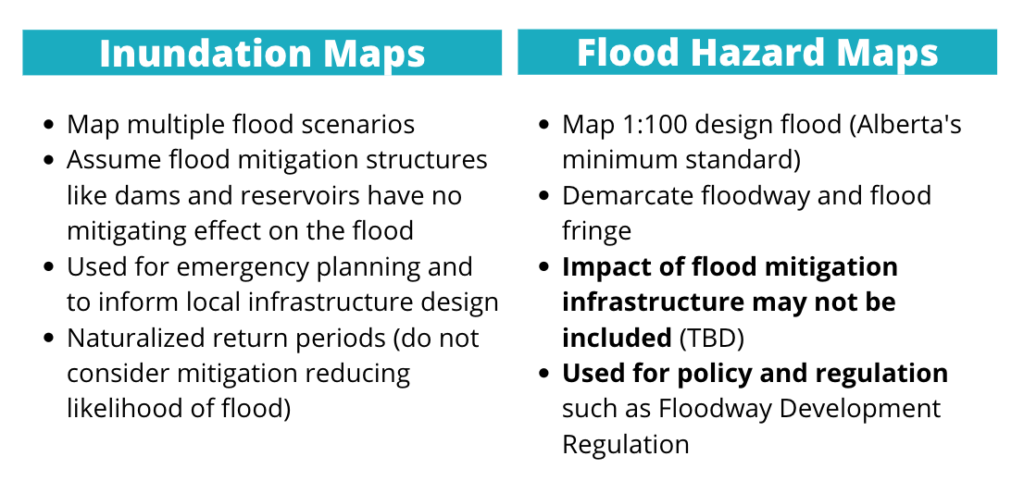
It is important to note that the draft maps are inundation maps NOT flood hazard maps — hazard maps are likely to come sometime next year.
The draft maps can be viewed easily in the Flood Awareness Map Application: https://floods.alberta.ca/?app_code=FI&mapType=Draft.
Build first… then map… then policy
We’ve always maintained that, in our view and regarding Elbow river communities, the government should first complete the Springbank-Off-Stream Reservoir before finalizing the applicable hazard maps or creating applicable land development policy based on these maps.
The flood hazard maps for Calgary haven’t been updated since the late 1980’s, so with SR1 completion on the horizon, why create new maps now when they will need to be changed?
We’ve talked about this before, but it is still unclear whether SR1’s flood protection will even be incorporated into the flood hazard maps.
We discuss this and more here: The risk of bad policy.
Additional information from AEP
On this matter, these important questions were asked at our AGM recently:
Q: How much time do you anticipate will elapse between the completion of new local flood mitigation projects and the publication of updated maps and land use bylaws?
A: We’d expect that Municipal land use regulation refinements can be enshrined into the City’s land use bylaw some time in 2022 or early 2023. Until then the City will inform any land use applicant of the sources of mapping information and make decisions with consideration to limit incremental accrual of risk. As community or regional mitigation measures are being implemented we will work with GoA to specify the relative risk reduction and incorporate it into flood hazard area approaches. (Answered by Frank Frigo, City of Calgary)
Q: The issue of flood mapping continues to be a contentious issue. How can flood maps be modified prior to mitigation, and if so, are they going to be modified after SR1 is completed or after Bow River mitigation is completed? Previous estimates of changes to floodplain mapping has caused tremendous concern for property owners, who for many, have been “red zoned” in preliminary mapping.
A: With regards to timing, I can say we’re working on options and assessing things already. We are working really hard and hopefully we’ll be able to share some new information next year as early as we can. Our intention is not years from now. I think we have a lot more understanding of how Albertans and Calgarians want maps updated to reflect new mitigation as it comes online, so I can’t foresee any map today not being updated for 30 more years if next year or three years from now major infrastructure is in place. We are working with the city and looking at options right now on how to update within months out years. The new berms that are in place and I can only say that we are working as hard and as fast as we can to look at how other larger-scale reservoirs and dams might play into updates. (answered by Peter Onyshko, Flood Hazard Specialist, AEP)
On the timing of sharing those inundation maps, its really important for emergency planning purposes that Calgary and its citizens understand what the risk is and where the water might go under different scenarios. It is really important for us to share that with our river forecasting centre and the City of Calgary’s forecasting centre and there is a public safety issue here. So that is urgency in sharing those inundation maps. The hazard maps I know there are other land use implications that cause people concern absolutely, but like Peter said those are coming down the road. (Answered by Carcey Hincz, Executive Director, Environmental Knowledge and Data Integration, AEP)
We will have more to come on flood mapping and policy as this develops. If you have any questions, let us know at info@crcactiongroup.com and we will do our best to get them answered.
Regards,
Your CRCAG Board