
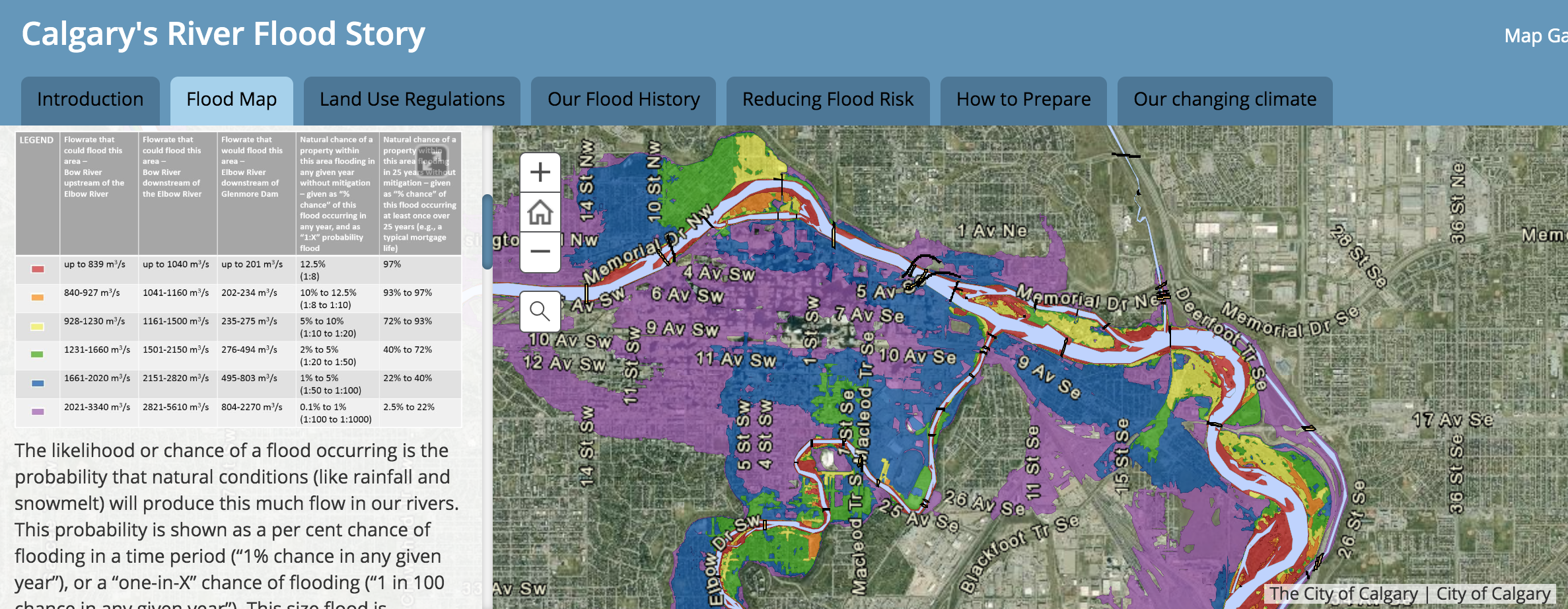
| Each year during flood season, the City of Calgary undertakes a flood readiness campaign to share flood-related information and resources. New this year: a river flooding story map and flood-themed walking tours. The river flooding story map is incredibly impactful and informative, especially the “flood map” tab. It’s why we’ve been at this for six years! |
We’ve shared the full City newsletter below. Additionally, you can find a roundup of flood season media coverage and events on our blog.
Regards,
Your CRCAG Board
The City of Calgary – Preparing for flood season
Every spring, as mountain snow accumulates and then melts, and rain storms start, we know that river flooding is top-of-mind for Calgarians. It is our priority at the City of Calgary to monitor, manage and reduce flood risk, and to ensure citizens understand their risk and have the resources available to prepare.
River flooding impacts all Calgarians who live, work, commute or recreate in the city centre or along the Bow and Elbow Rivers. River flooding is most likely to occur between mid-May and mid-July.
We actively monitor river, weather and snowpack conditions to prepare for potential flooding. It is important to note that:
- Heavy rainfall in our mountains and foothills has the biggest influence on river flood risk.
- Snowmelt from the mountains can cause high river flows, but snowmelt alone does not cause our rivers to flood. The snowpack in the mountains has been average to below average this year.
- The City and Province continuously monitor for conditions that can develop into flood events.
We cannot stop river floods from happening, but we can reduce their impact.
Since 2013, The City, in partnership with the provincial and federal governments, has committed more than $300 million towards projects that will reduce our risk of river flood damage. We continue to strengthen our understanding of the flow of the Bow and Elbow Rivers, how rivers change, flood modelling, forecasting, preparedness and response.
The City’s three-part Flood Resilience Plan, approved by Council in 2017, is based on extensive technical studies and public engagement. The City’s goal is to protect our city from a flood at least as big as the one we experienced in 2013. The three parts of this plan, working together, will help us meet that goal and include:
- Capturing more floodwater before it gets to Calgary via new reservoirs, built by the Province, and through the operation of existing reservoirs upstream of the city on the Bow and Elbow Rivers.
- Keeping floodwater out of the most vulnerable communities through the construction of local flood barriers.
- Reducing the risk of property damage by implementing updates to development regulations and by encouraging citizens to take actions to prevent damage to their properties.
Everyone has a role, and we must all understand, prepare and stay informed about river flooding.
Floods happen quickly and with little warning. We must be ready to respond quickly in a flood situation. You can prepare yourself and loved ones by listening to alerts and the media, and evacuating when requested. Your cooperation ensures everyone stays safe, including our emergency responders.
On your property, follow regulations if you are in a flood zone. Consider building practices that decrease the likelihood of damage during the next flood.
Visit Calgary.ca/floodinfo for more information, to explore our new interactive River Flooding story map, sign up for our e-newsletter and walking tours, and download our Flood Readiness Guide.