What’s happening?
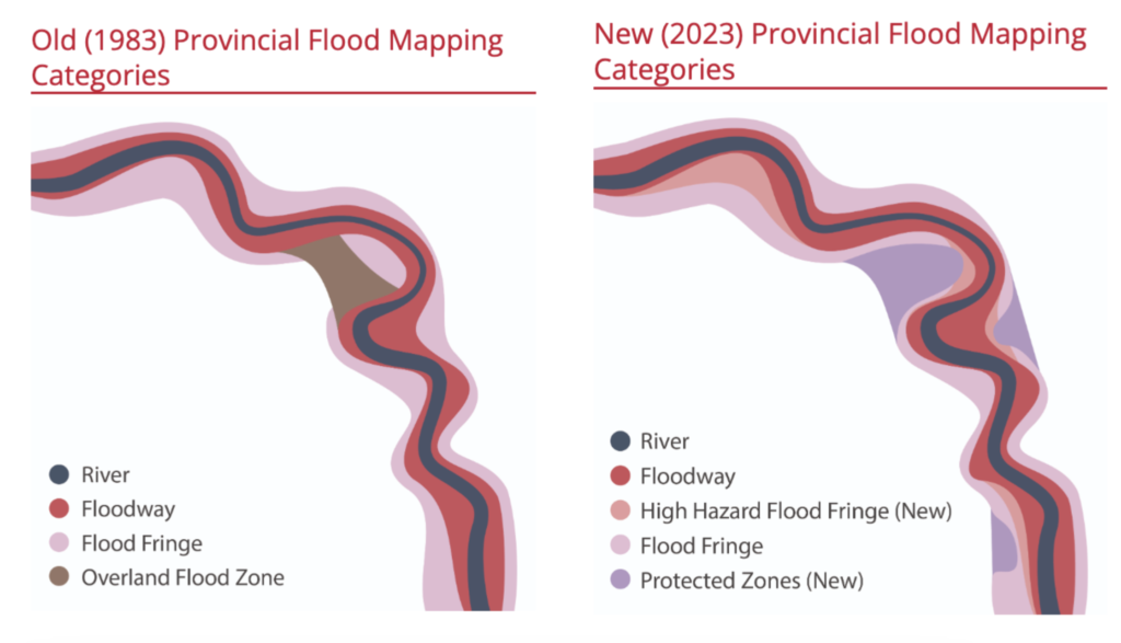
The Government of Alberta recently released draft updated Flood Hazard Area maps reflecting the latest understanding of flood risk across Alberta, and a new approach to flood hazard area zones. All flood hazard area zones are defined to reflect a 1:100 flood, which is the provincial design flood standard. Essentially, how would water flow away from a river experiencing a 1:100 year flood event?
In the new approach, the Province has defined three degrees of Flood Fringe hazard area zones: High Hazard Flood Fringe, Flood Fringe and Protected Flood Fringe representing high, medium and low/no (due to mitigation measures) flood hazard, respectively.
It’s now up to the City to decide how to regulate land development in each of these areas, which they are doing through the Calgary River Valleys Project (CVRP). Another flood hazard area zone is the Floodway which is an area of extreme risk and it is expected that new development will be for the most part prohibited in it.

Any decisions on how to develop and regulate in these areas will be embedded in the new Calgary Plan and in our Land Use (Zoning) Bylaw.
The City of Calgary is inviting public feedback on future floodplain policies and regulations via engagement opportunities between January 29 to March 3 (via the Calgary River Valleys Project).
View the draft Flood Hazard Maps here: https://floods.alberta.ca/?app_code=FI&mapType=Draft
Participate in the CRVP public engagement opportunities here: https://engage.calgary.ca/rivervalleys
Read more below about Calgary River Valleys Project and the specific engagement opportunities.
Context and concerns
What do I need to consider before providing feedback?
“Generally, floodplain planning aims to reduce the number of people living in flood impacted areas, especially areas where a higher risk of flooding remains” (CRVP website). This means restrictions to development in areas deemed to be at high risk of flooding.
How the City decides to regulate flood hazard areas may very well impact property use, property values, limit the ability to insure a property or renew a mortgage. Regulations will also impact retaining or adding secondary suites, density restrictions that may dictate types of dwellings allowed in zones, building and site design restrictions (e.g. location of critical infrastructure), building footprint (fencing and other structures), and more.
The two new areas to be regulated are:
High Hazard Flood Fringe
Protected Flood Fringe
We must pay close attention to what happens with these two new areas and the City’s approach to flood hazard mapping in general.
Where can I find what regulations are being proposed?
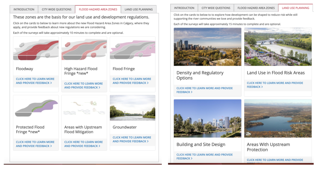
Dig into the https://engage.calgary.ca/rivervalleys page, with particular emphasis on the “Flood Hazard Area Zones” and “Land Use Planning” tabs. The links in the boxes under these tabs are where the guts of the proposals are set forth. Work your way through all of these boxes to complete the survey.

Community-specific considerations
For any community now classified with this new High Flood Hazard label, new rules could lead to development restrictions in the affected areas, which could be as severe as “no new development”.
Sunnyside-Hillhurst — Until the Sunnyside Flood Barrier is complete, much of Sunnyside and even part of Hillhurst will be classified as high risk High Hazard Flood Fringe. Still more of Sunnyside will be included in the medium risk Flood Fringe classification. The “official” date for completion of the Sunnyside Flood Barrier is the end of 2025, although there have been recent signals from the City that this schedule might slip, perhaps significantly.
Bowness — With the new maps, areas of Bowness have been labeled High Hazard Flood Fringe. With the Bow River Reservoir Project still more than a decade out, regulations from the new maps will be in place for the foreseeable future. Even once any new Bow Reservoir is operational, because the infrastructure will not be dedicated to just flood protection, but rather drought mitigation as well, the maps may not be refreshed to reflect Protected Hazard Area. We expect that further discussions on this issue will progress in the future.
Remember: The Province released the Calgary Flood Hazard Area map for the Elbow River with the new designations removed, until the Springbank Off-stream Reservoir (SR1) is operational and new mapping can be modeled. Therefore, we can not report on the new designation areas (High Hazard Fringe and Protected Area for many other communities). Please see our post here.
Opportunities for engagement until March 3
The engagement campaign is active now until March 3, with in-person and virtual opportunities. To obtain more information and have your say, please attend one of the public engagement sessions, or participate in online engagement.
Two Virtual Sessions:(1) January 31 (6 – 7 p.m.)
(2) February 13 (6 – 7 p.m.)
Visit calgary.ca/RiverValleys to register for a virtual session.
Three In-person “drop-in” Sessions:
(1) Bridgeland Community Association (917 Centre Ave NE)
Feb. 21 5 – 8 p.m.
(2) Parkhill/Stanley Park Community Association (4013 Stanley Rd SW)
Feb. 27 6 – 9 p.m.
(3) Montgomery Community Association (5003 16 Avenue NW)
March 1 5 – 8 p.m.
Access to the online survey will be through calgary.ca/RiverValleys.
About the Calgary River Valleys Project
The purpose of the Calgary River Valleys Project is to provide guidance for decisions about how Calgary plans, uses, conserves and builds in its river valleys. The goal is to create coordinated and purposeful land use policies. These policies may make use of a range of levers, including reserves, setbacks, densities and different types of land uses.
Thus, the Calgary River Valleys Project is about much more than flood hazards. Read all about the Nature, Recreation & Access, Culture and Building & Development aspects of the CRVP on its website calgary.ca/RiverValleys.
Thank you for your attention to this matter and we encourage you to submit your comments via the public engagement channels we’ve described above. We will be sure to update you as we receive any new information on this file.
Regards,
Your CRCAG Board

